Irene Approaches
I spoke with my brother again this morning and he says they have Mom’s house buttoned down to ride out Hurricane Irene.
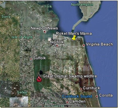
There is one positive aspect of this storm.The torrential rains will aid firefighters who have been battling the Great Dismal Swamp wildfire which was started by a lighting strike two weeks ago. So far it has burned over 5,500 acres. Smoke from the fire has triggered air quality alerts 200 miles away!
Hurricane Warning
Flood Watch
Hazardous Weather Outlook
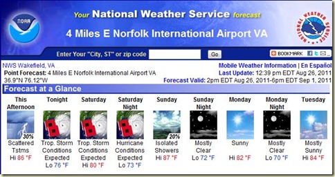
This Afternoon: Scattered showers and thunderstorms. Mostly cloudy, with a high near 86. East wind around 11 mph. Chance of precipitation is 30%. New rainfall amounts of less than a tenth of an inch, except higher amounts possible in thunderstorms.
Tonight: Tropical storm conditions expected, with hurricane conditions possible. Scattered rain and thunderstorms, then rain likely and possibly a thunderstorm after midnight. Some of the storms could produce heavy rainfall. Cloudy, with a low around 76. East wind 11 to 16 mph increasing to between 29 and 39 mph. Winds could gust as high as 46 mph. Chance of precipitation is 60%. New rainfall amounts between three quarters and one inch possible.
Saturday: Tropical storm conditions expected, with hurricane conditions possible. Rain and possibly a thunderstorm. Some of the storms could produce heavy rainfall. High near 80. East wind 45 to 55 mph, with gusts as high as 65 mph. Chance of precipitation is 100%. New rainfall amounts in excess of 4 inches possible.
Saturday Night: Hurricane conditions expected. Rain and possibly a thunderstorm. Some of the storms could produce heavy rainfall. Low around 73. North wind 60 to 80 mph decreasing to between 45 and 55 mph. Winds could gust as high as 95 mph. Chance of precipitation is 100%. New rainfall amounts in excess of 4 inches possible.
Sunday: Isolated showers before noon. Mostly sunny, with a high near 87. Windy, with a west wind between 24 and 30 mph. Chance of precipitation is 20%.
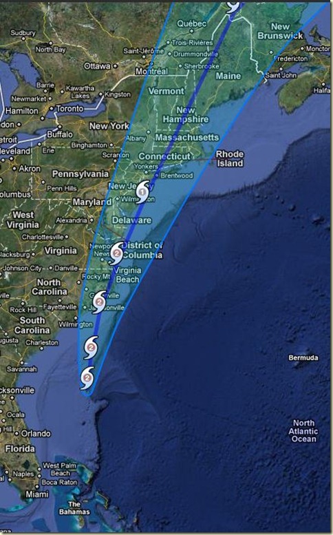
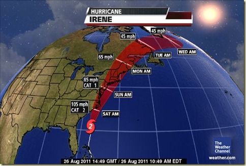
The latest updates have Irene moving across the Hampton Roads (Tidewater to locals), Virginia area tomorrow afternoon as either a weak category 2 or strong category 1 hurricane.
Saffir/Simpson Hurricane Scale
|
CAT |
Winds & Effects |
Surge |
|
1 |
74-95 mph |
4-5 ft. |
|
|
No real damage to building structures. Damage primarily to unanchored mobile homes, shrubbery, and trees. Also, some coastal flooding and minor pier damage. |
|
|
2 |
96-110 mph |
6-8 ft. |
|
|
Some roofing material, door, and window damage. Considerable damage to vegetation, mobile homes, etc. Flooding damages piers and small craft in unprotected moorings may break their moorings. |
|
|
3 |
111-130 mph |
9-12 ft. |
|
|
Some structural damage to small residences and utility buildings, with a minor amount of curtain wall failures. Mobile homes are destroyed. Flooding near the coast destroys smaller structures with larger structures damaged by floating debris. Terrain may be flooded well inland. |
|
|
4 |
131-155 mph |
13-18 ft. |
|
|
More extensive curtain wall failures with some complete roof structure failure on small residences. Major erosion of beach areas. Terrain may be flooded well inland. |
|
|
5 |
155 mph+ |
18 ft. + |
|
|
Complete roof failure on many residences and industrial buildings. Some complete building failures with small utility buildings blown over or away. Flooding causes major damage to lower floors of all structures near the shoreline. Massive evacuation of residential areas may be required. |
|
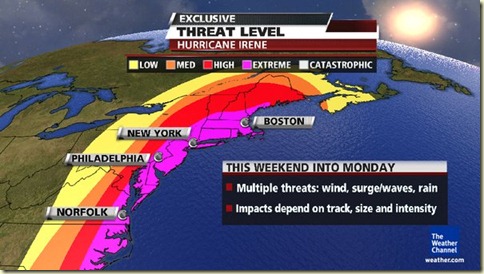
Mom lives just east of Norfolk, in the extreme threat area on the map above.
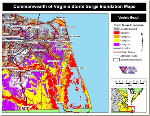
In addition to sustained hurricane force winds the area is predicted to get 8+ inches of rain with a 4 to 8 foot storm and unusually high lunar tides. I may need to borrow Fish Hook’s boat as well as his utility trailer if I get a call to bring in supplies to repair storm damage.
Now all we can do is wait and pray.

I’m praying for you and your family. And those aren’t empty words!
August 27, 2011 at 1:11 AM
Thanks, Nannette 🙂
August 28, 2011 at 11:18 AM
You and your family are all in my thoughts and especially your mom right in the path as she appears to be! I’ve been trying to access your blog all day but W/P is being stupid and said it had been deleted?? Found it on the mobile so I know it wasn’t true. Blocked content on various blogs…W/P not working or anything related to that category…I think it’s pulled the shutters down in anticipation of the hurricane conditions. However it does seem to be up and running again now…so far 😉
Stay safe and keep us posted when you can so we know you and yours are doing ok. Big protective Wolfie hugs for you all! 🙂
August 27, 2011 at 4:49 PM
Thanks, Wolfie. WP went stupid for a while yesterday. When I published this post it appeared in my browser, just like it always does but after I got an e-mail asking why I deleted it (and I hadn’t) I took a look and discovered it posted as a draft. Not sure how that happened but I got it fixed……..I hope.
August 28, 2011 at 11:21 AM
Storm has passed, there are trees down, power is out and what flooding they got is receding. Mom’s home came through unscathed and the family is okay!
August 28, 2011 at 11:22 AM
How’s everything, honey?
Miss you… but I’m so busy…
Wish you joy and love.
Warm hug from Brasil.
August 28, 2011 at 8:22 PM
I’m glad everyone is safe and well. I dunno, an earthquake then Hurricane Irene…just what is next???
August 29, 2011 at 12:15 PM
Hurricane Wolfie!! 😉
And that’s going to be a real howler!
Button down RM!
You aint seen nuthin yet!!! 😉
August 29, 2011 at 7:07 PM